


Google Maps just dropped what they’re calling the most transformative update in over a decade, packed with jaw-dropping 3D visuals, conversational AI smarts, and hyper-realistic navigation tools tailored for chaotic Indian roads and sprawling American highways. This isn’t just a facelift—it’s a complete rethink of how we explore, drive, and plan trips, blending fresh Street View data with Gemini AI to make every journey feel personal and predictive. Whether you’re dodging Delhi traffic or cruising California freeways, these changes promise fewer wrong turns and more “wow” moments.
The Genesis of Google Maps’ Bold Redesign
Announced in early March 2026, this overhaul stems from years of user feedback on navigation frustrations—like missing subtle lane shifts or hunting for context in flat maps. Google crunched data from billions of daily interactions, incorporating five million real-time traffic signals per second to build smarter, more lifelike interfaces. The rollout kicks off in the USA with full Android/iOS support, extending to CarPlay, Android Auto, and in-car systems over the next few months, while India jumps ahead on AI-driven planning features.
What sets this apart? It’s not random tweaks but a unified vision: deeper immersion during drives, effortless querying for plans, and proactive alerts that anticipate your needs. For instance, imagine seeing elevated overpasses in full 3D glory before you hit them, or AI suggesting a scenic detour based on your love for street food. This builds on 2025’s India-first experiments, like highway incident warnings from NHAI data, now supercharged globally.
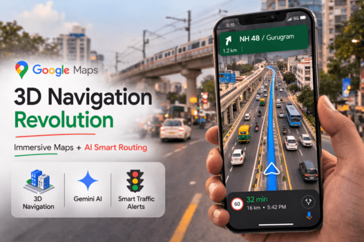
Immersive Navigation: From 2D Flatness to 3D Lifelike Roads
At the heart is Immersive Navigation, evolving Google Maps’ classic Live View into a full-screen 3D spectacle that redefines driving. Picture this: as you approach a busy interchange, the map seamlessly renders photorealistic buildings with transparent edges, letting you “see through” structures to spot upcoming exits, pedestrian crossings, and traffic signals from Street View panoramas and satellite overlays.
Key visual upgrades include:
-
Dynamic 3D Rendering: Buildings, trees, bridges, and road textures pop with seasonal accuracy—think snow-dusted peaks in the US Rockies or monsoon-flooded underpasses in Mumbai.
-
Lane Precision Overlays: Clear markings for HOV lanes, bus-only paths, or cycle tracks, with glowing highlights for your required lane up to 150 meters ahead.
-
Smart Zoom and Tilt: The view auto-adjusts zoom levels for highways (wide overview) versus city streets (tight focus), tilting for elevation changes like ramps or hills.
-
Augmented Landmarks: Icons for hospitals, schools, or temples pulse during relevant turns, synced with natural voice prompts like “In 200 meters, take the next left after the blue mosque.”
Traffic intelligence amps it up: compare routes with specifics (“Option B: 5 minutes faster, 10% less congestion, avoids construction”), get instant crash notifications with detour previews, and even parking lot flyovers showing available spots. In India, where two-wheelers weave unpredictably, this could slash accidents by clarifying merges; US users tackling interstates will appreciate the elevated flyover visualizations that make spaghetti junctions intuitive.
Rollout phases mean testing in major metros first—Manhattan for density, Bengaluru for volume—before nationwide push.
Ask Maps: Gemini AI Turns Queries into Custom Adventures
Forget typing rigid searches; Ask Maps introduces a chat-like interface powered by Google’s Gemini models, understanding context from your history, location, and preferences. Type or speak naturally: “Find pet-friendly cafes en route to Agra with good lighting for work,” and it spits out ranked options with photos, ratings, menus, EV charging status, and integrated bookings.
Detailed capabilities:
-
Multi-Leg Trip Builder: “Weekend getaway from Delhi to Rishikesh with yoga spots, rafting, and veg thalis under ₹2000” generates day-by-day itineraries, toll calculators, fuel stops, and weather-tied alternatives.
-
Personalization Engine: Learns from past trips—if you skip chains for local gems, it prioritizes mom-and-pop shops; EV drivers get charger reliability scores from user reports.
-
Hands-Free Mode: Voice-activated in-car queries like “Avoid tolls and traffic for the next hour” with follow-ups: “Make it scenic?”—all without lifting eyes from the road.
-
Review Synthesis: Pulls from 500 million+ reviews to answer “Is this place family-friendly?” with pros/cons, recent trends (e.g., “Newly added kids’ menu, but crowded weekends”).
India leads with English rollout now (Hindi/ regional languages imminent), tying into local gems like metro ticket buys in NCR cities or speed trap alerts in nine metros. USA gets desktop expansion soon, ideal for road trip plotting from laptops. Privacy-focused, it processes queries on-device where possible, only cloud-dipping for complex plans.
India vs. USA: Customized Rollouts for Local Chaos
Google’s tailoring shines regionally:
| Feature Category | USA Highlights | India Highlights | Shared Wins |
|---|---|---|---|
| Visuals & 3D | Highway overpasses, urban skyscrapers in 3D; parking previews nationwide. | Monsoon-ready road textures, temple/station landmarks; metro overlays in Delhi/Mumbai. | Transparent buildings for turns |
| AI Planning | Vacation blueprints (e.g., Yellowstone loops), EV networks. | Local eats/charges (e.g., chaat stalls, Rapido integration), budget itineraries. | Natural language queries |
| Traffic Tools | Interstate alerts, construction ETAs. | NHAI incidents, speed cams in 9 cities, auto disruptions. | Route tradeoffs |
| Timeline | Immersive now; full cars Q2 2026. | Ask Maps live; Immersive Q2. | Updates weekly. |
India’s edge? Builds on 2025’s 10 innovations like proactive jams and incident sharing, now AI-enhanced for Gurugram gridlock. USA emphasizes scale for coast-to-coast reliability.
Everyday Wins: Solving Navigation Nightmares
For Tighri folks battling NCR snarls, 3D previews flag pothole-prone alleys or U-turns early; imagine AI whispering “Switch to service road—saves 8 minutes.” US truckers get overpass height warnings, preventing costly scrapes. Families love photo-rich plans that include playground stops; cyclists see bike lane gaps highlighted.
Battery optimizations ensure it runs smooth on mid-range phones, with offline 3D caching for spotty signals—crucial in rural Rajasthan or remote Appalachia. Community contributions keep data fresh, rewarding top reporters with badges.
Ties to Broader Google Ecosystem
This syncs with 2025’s map style refresh—brighter icons, simplified colors—and Pixel/WearOS deep integration for glanceable ETAs. Gemini ties mean cross-app magic: start a plan in Gmail flights, refine in Maps. Future teases include AR walking overlays and weather-reactive routing.
Why Update Now? SEO, Safety, and Buzz
Search “Google Maps 3D India 2026” spikes show hype—your blog taps it with fresh insights. Safety stats? Early tests claim 20% fewer lane errors. Update via Play Store/App Store; enable Labs for betas.
What changed your last drive? Will 3D conquer Mumbai monsoons or NYC blizzards? Comment your predictions, share screenshots, and subscribe for rollout trackers!